

Maze Hill
The double-track London & Greenwich Railway (L&GR) commenced operation between Spa Road (Bermondsey) and Deptford on 8th February 1836 (ref: Bradshaw’s Railway Manual, 1850). A westward extension to London Bridge was opened with ceremony on Wednesday, 14th December of the same year (ref: Sun (London), 15th December 1836); the remaining section between Deptford and Greenwich came into use on 24th December 1838, giving the railway an end-to-end length of 3-miles 60-chains, with an average journey time of fifteen minutes (ref: The Railway Shareholder’s Manual to the Railways of Great Britain, Henry Tuck, 1845). By an Act of Parliament passed on 21st July 1845, the L&GR was leased to the South Eastern Railway (SER) for a period of 999 years (ref: The Railway Shareholder’s Manual to the Railways of Great Britain, Henry Tuck, 1845). On 30th July 1849, the latter opened its North Kent Line to Dartford, Gravesend, and Strood, which left the original L&GR 2½-miles south east of London Bridge and passed through Lewisham, Blackheath, and Woolwich. The SER’s preference had been to start the North Kent Line at Greenwich, which required a tunnel under Greenwich Park, east of the existing terminus; however, newspaper articles dating from 1846 cited the Royal Observatory’s concerns over vibrations from trains impacting their work. This forced the SER to pursue a circuitous route via Lewisham.
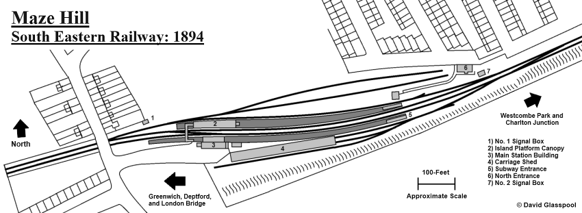
Two signal boxes are shown, as is the position of the original footbridge and carriage shed. Click the above for as larger version. © David Glasspool
The Royal Observatory’s stance had left the people of Greenwich at the end of a long siding, and to get down into Kent required journeying in the opposite direction to London Bridge, or a long walk to Lewisham or Blackheath stations. A scheme by the name of the Greenwich and Woolwich Railway surfaced in 1860: a prospectus issued by the company showed a capital of £200,000 for a line commencing at a junction with the existing Greenwich branch and ending at or near the SER's Charlton station on the North Kent Line (ref: The Morning Herald (London), 15th August 1860). A bill was declared to Parliament for the scheme in January 1863 (ref: Sun (London), 27th January 1863), but in the following month it was withdrawn (ref: Sun (London), 17th February 1863). The scheme was not affiliated with the SER.
By an Act dated 5th July 1865, the SER was authorised to construct a line between Greenwich and Charlton. As part of a subsequent Act dated 1st August 1870, the company was granted more time to complete the line; a further time extension was granted by an Act of 25th May 1871 (ref: Bradshaw’s Railway Manual, Shareholders’ Guide, and Official Directory for 1878). The 1-mile 10-chains of railway between Charlton Junction and Maze Hill, the latter positioned adjacent to Greenwich Park, was opened to public traffic on 1st January 1873 (ref: Chichester Express, 21st January 1873). The SER secured another time extension to complete the rest of the line, by an Act dated 26th May 1873, which gave the company exactly two years from that date to finish the works (ref: Bradshaw’s Railway Manual, Shareholders’ Guide, and Official Directory for 1878). Completion between Maze Hill and Greenwich did not come until 1878, this section diverging from the original branch line near Deptford Creek: it opened to local traffic on 1st February of that year and to through traffic on 1st March (ref: Bradshaw’s Railway Manual, Shareholders’ Guide, and Official Directory for 1882). The multiple applications for time extensions was a result of the SER’s reluctance to build the line — the company had considered abandoning it.
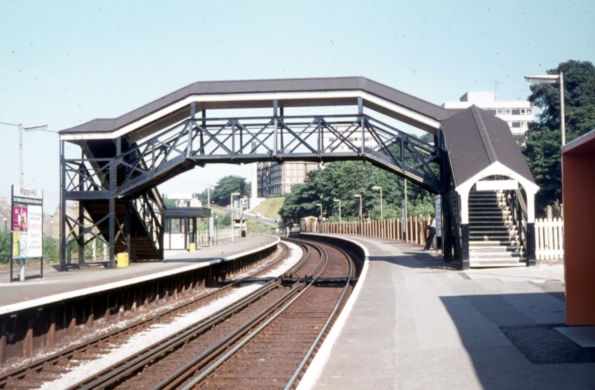
5th February 1955

A southward view from the island platform includes an SE&CR "Birdcage" carriage set being sheltered by the arched carriage shed roof that was located behind the "up" platform. The August 1926 edition of "The Railway Magazine" refers to the structure as a "carriage cleaning shed". In the earliest years, the platform’s side — seen here being of prefabricated concrete construction — was faced with timber. An electric lamp, complete with barley twist post and "Target" name sign, is in evidence — in the earliest years, the station received a daily supply of two gas cylinders in a wagon to fuel the lighting. © David Glasspool Collection
The SER’s Maze Hill station took its name from the adjacent road that runs along the eastern perimeter of Greenwich Park. At the SER’s half-yearly meeting at the City Terminus Hotel, Cannon Street on 24th July 1873, it was stated that the station had generated a passenger traffic of 78,000 since it had opened in January of that year (ref: Herepath’s Railway Journal, 26th July 1873). As the diagram on this page attests, the layout that manifested in the late 19th Century was an extensive one for what had become an intermediate station on a three-mile stretch of line. The sidings were used for carriage berthing — no goods facilities having ever been available here — and were presumably a legacy from when the station was a terminus at the end of the branch from Charlton. As illustrated on the diagrams on this page and evident in the first photograph, two of the sidings — situated south of the running lines — were roofed, albeit with sides exposed.
A complication of describing the layout at Maze Hill is that of what to refer to as "up" (London-bound) and "down" (Kent-bound) sides. In the earliest years, the positions of "up" and "down" tracks was reversed between London Bridge and Charlton via Greenwich — i.e. trains ran in the direction of travel on the right-hand of the two tracks of this line, rather than adopting the conventional left-hand running (the latter of which is in place today). So, what today is the "up" platform originally served trains running in the "down" direction. The April 1900 edition of The Railway Magazine explained that the SER had three tracks upon the viaduct that ran to London Bridge, two "up" and one "down", and that it was found more convenient to work the traffic with the "down" line in the centre, instead of the "up" Greenwich line crossing the "down" line at the junction with the North Kent Line. This practice ceased on and from Sunday, 26th May 1901, when left-hand running between London Bridge and Charlton via Greenwich commenced (ref: The Railway Magazine, July 1901). For the purposes of this section, your author will refer to "up" and "down" sides in the post-1901 sense, as is the case today.
5th February 1955
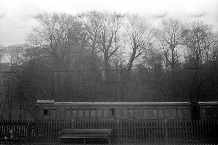
Moving to the left (east) of the previous view, the end of another "Birdcage" carriage set is seen, in a decidedly rural spectacle. The trees in the background still exist, but the area in-between these and the station is now occupied by blocks of flats. In the earliest years, the largest platform nameboard read "Maze Hill For East Greenwich". © David Glasspool Collection
Three platform faces were in evidence at the station, two of which formed an island on the northern side of the running lines. The main building was situated on what is today the "up" platform, on the southern side of the tracks. Single-storey with a hipped slated roof, this structure was of brick construction, but clad with timber on its platform-facing elevation. It sported a flat-roofed canopy, which comprised the same style of spiked decorative valance as that still evident today at St John’s and Erith. On the island platform, a canopy with a semi-circular cross-section (as per today’s canopies at Paddock Wood) was evident, which was also equipped with a spiked valance. Positions are marked on the diagrams on this page.
5th February 1955

A northward view from the island platform includes part of another "Birdcage" set, this time in the "down" sidings. Note the silhouette of the intricate island canopy valance, which was replicated on the main station building. This valance design can still be seen today at Erith and St Johns. © David Glasspool Collection
Unusually for the time, the platforms were linked by both a subway and footbridge. The former was situated at the eastern extremity of the station and, at platform level, the staircases were surrounded on three sides by a low brick wall that supported a curved roof — this same style of subway entrance/exit can still be seen at Northfleet. The subway was linked to a pathway that provided an entry route to the station from the north. At this northern entrance, a single-storey yellow brick building with hipped slated roof was erected — this still exists today, albeit let out for commercial use. The footbridge was situated on the western side, and adjacent to, the station buildings, and comprised a curved roof.
Signal boxes were present east and west of the station and are marked on the diagrams. The cabin situated at the eastern end of the layout was built to an in-house SER design: two-storeys-high, it was of all-timber construction with a hipped slated roof and the company’s favoured sash-style windows. This signal box can be glimpsed in one of the photographs on this page from 1955. Based on your author’s observation of a photograph from about 1900, which includes the rear of the cabin at the western end of the layout, this was also two-storeys-high, the upper level at least being of timber construction and being topped off with a hipped roof.
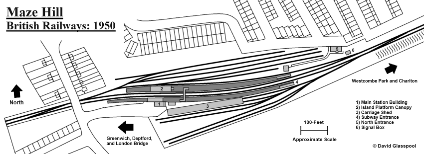
Compared to the plan from 1894, more sidings have been laid on both sides of the station — these were in place by 1914. The extent of the platform buildings has been reduced, presumably as a result of war damage, a new footbridge erected east of its predecessor, and No. 1 signal box long gone. Click the above for a larger version. © David Glasspool
On 19th July 1926, the Southern Railway (SR) introduced a full electric passenger timetable on all North Kent routes to Dartford (ref: Southern Electric 1909-1979, G.T. Moody). The company also closed the signal box at the western end of Maze Hill on 4th February 1934 (ref: Volume 4 Southern Railway Register, Section A8: North Kent East Junction to Maidstone West via Erith, The Signalling Record Society). A conundrum that your author has is determining the origin of today’s footbridge, and whether or not it was an SR product. He accepts that Ordnance Survey maps are not always accurate when it comes to railway details: editions that mark the line as "SR" and show the west signal box still in place also depict the original footbridge on the Greenwich side of the station structures. Today’s footbridge, which was erected east of the canopies, is very similar in appearance to that which was erected by the SR at Eltham Park in 1924; so, perhaps Maze Hill’s is a product of the same company.
London County Council Bomb Damage maps for the period 1939 to 1945 show that the main building at Maze Hill suffered general blast damage during the war. Indeed, post-war photographs show the structure to be about half its original length, canopies on both platforms being truncated at their western ends — a general air of dereliction, as a result of conflict damage.
5th February 1955
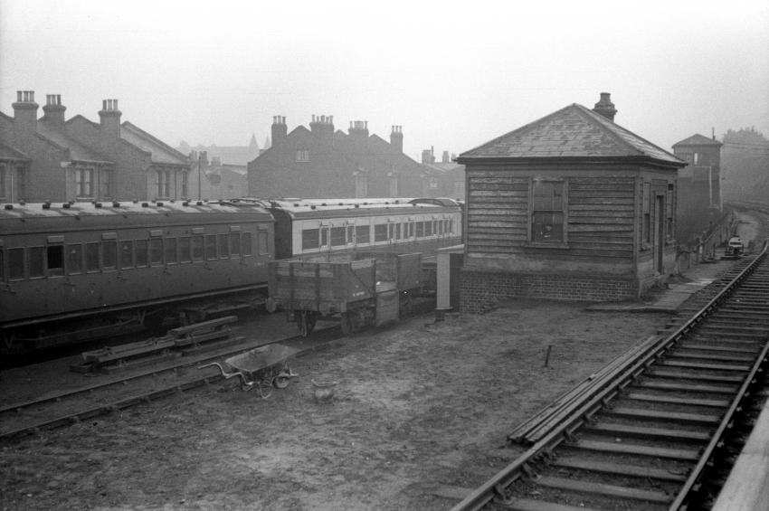
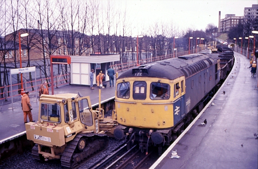
The sidings were used mainly for storing passenger steam-hauled stock that was required for weekend work and special trains. This Charlton-bound view from the island platform includes occupied "down" sidings and, in the right background, the signal box. © David Glasspool Collection
Maze Hill station’s most notable event in history is undoubtedly that of a collision that took place at 10.25 A.M. on Friday, 4th July 1958. A Bulleid-designed 4-EPB electric unit forming the 9.41 A.M. Gravesend Central to Charing Cross service — from which six carriages had been detached at Slade Green — passed the "up" home signal at danger. At a speed of about 25 MPH, the unit collided with "C" Class steam locomotive 0-6-0 No. 31461, which was facing in the Charlton direction on the "up" line shunting nine empty carriages from the "up" sidings. No. 31461 was in the process of hauling the carriages to the "down" line, having entered the crossover at the time of the collision. The force of the collision pushed the empty stock train back eleven yards and caused the steam locomotive to be lifted and mount the driving vehicle of the electric unit. There were no serious injuries, although 43 of the 50 passengers in the electric unit were taken to hospital, in addition to the motorman and guard. The line was cleared after a blockage of about nine-and-a-half hours (ref: Report on the collision which occurred on 4th July 1958 at Maze Hill in the Southern Region British Railways, Railway Accidents, Ministry of Transport and Civil Aviation, 19th December 1958).
In the July 1969 edition of the RCTS’ The Railway Observer, it was reported that disconnection of the last remaining siding and crossover at Maze Hill was taking place. Track rationalisation was in connection with the resignalling of the North Kent routes. The signal box beyond the eastern end of the station closed on 29th November 1969 (ref: Volume 4 Southern Railway Register, Section A8: North Kent East Junction to Maidstone West via Erith, The Signalling Record Society) and colour light signalling came into use between Greenwich and Westcombe Park on 8th March 1970 (ref: Southern Electric 1909-1979, G.T. Moody).
15th July 1972
This Charlton-bound view from the "up" platform shows the station a year after rebuilding. The entrance to the then new main building from the platform can just be seen in the immediate foreground on the extreme right. Beyond the footbridge can be seen a CLASP shelter on the "down" platform, and further still are railings along the northern side of the former island, which were in place by 1958. In the distance can also be seen the disused entrances to the subway: that at the end of the "down" platform was bricked up and its "up" counterpart fenced off from the station. The SER subway surrounds had gone — your author suspects that they were rebuilt shortly after the war. © David Glasspool Collection
A fire in 1971 damaged the main station building, so the opportunity was taken to completely replace it. On 14th July of that year the then new "up" side station building was opened, this of which was equipped with electronically-worked barriers (Southern Electric 1909-1979 G.T. Moody). The structure was a single-storey cuboid with all sides glazed, and similar buildings were commissioned at Chelsfield and Elmers End. The "down" (former island) platform’s decaying canopy was taken down and replaced by a CLASP waiting shelter situated east of the footbridge, and metal lampposts were installed on both platforms. It had been a bumpy start to the 1970s for the station: in April 1970, a gang of burglars broke into the ticket office, tied up the clerk, and stole £200 (ref: Daily Mirror, 13th April 1970).
December 1989
Track relaying is in progress in this Charlton-bound view, which includes Class 33 No. 33052 "Ashford". The CLASP shelter was still in existence on the "down" platform and the former site of the carriage sidings north of the platforms had been redeveloped for residential use. The former subway entrances are still evident in the background. © David Glasspool Collection
Street maps from the early 1980s show that the area north of the station, formerly occupied by the "down" carriage sidings, had been redeveloped for residential use. By 1993 a curved-roof glazed shelter, about 15-feet-long, had been installed by business sector Network SouthEast on the "up" platform, in-between the main building and footbridge. About ten years later, a "Paragon Anti-Vandal" waiting shelter appeared on the "up" platform, west of the main building.
3rd July 2006

Platforms aside, the oldest structure in this eastward view is the roofed footbridge. The glazed cuboid has housed the ticket hall since 1971 and British Rail erected similar structures at Elmers End and Chelsfied. An in-house British Rail design, the type of building was formally classed "D70". The blocks of flats in the right background are built on the former site of the "up" carriage sidings. Railings had been completed at the London end of the northern edge of the former island platform face by this time. © David Glasspool
Station Masters
- Henry David Smart was noted as Station Master in 1880 (ref: The Kentish Independent, 14th August 1880).
- Samuel Parkes became Station Master in 1891, succeeding the late Mr Smart. Mr Parkes had started at Maze Hill as a guard on completion of the through line in 1878. He was promoted to inspector at the same station in 1885, then Station Master in 1881. It was reported at the time that it was a very rare event in the history of the SER for anyone to have three succeeding positions at the same station (ref: The Brockley News, 8th October 1897).
- Mr Parkes retired in 1913, after over fifty years of service with the SER/SE&CR (ref: Woolwich Gazette and Plumstead News, 22nd April 1913). He was replaced by Mr F. W. Blackbourn, who was promoted from his existing position as Station Master at Slades Green (ref: Woolwich Gazette and Plumstead News, 13th May 1913).
- Mr Blackbourn retired on 10th December 1922, after over forty years of railway service. He was succeeded as Station Master at Maze Hill by Mr J. Baldwin of the District Superintendent’s office at London Bridge (ref: The Kentish Independent and Kentish Mail, 3rd November 1922).
- In 1928, Mr Baldwin was promoted to Station Master at Coulsdon. By that time, Maze Hill, Greenwich, and Deptford were under a single Station Master. The Southern Railway appointed George Boozer to succeed Mr Baldwin at these three stations. Until that time, Mr Boozer was Station Master at Merstham (ref: Surrey Mirror and County Post, 6th July 1928).
- Mr Alfred John Leaper was noted as Station Master of Deptford, Greenwich, Maze Hill, and Westcombe Park until 1942, when he was promoted to the same position at Blackheath, Lewisham Junction, and Kidbrooke (ref: Lewisham Borough News, 11th August 1942).
- B. H. Highwood was noted as Station Master of the mentioned Greenwich stations in 1958 (ref: Report on the collision which occurred on 4th July 1958 at Maze Hill in the Southern Region British Railways, Railway Accidents, Ministry of Transport and Civil Aviation, 19th December 1958).
3rd July 2006
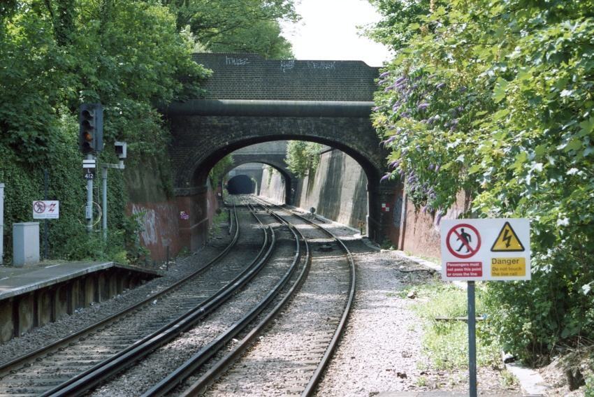
A brick-lined cutting west of the station is followed by Greenwich College Tunnel, the latter 450-yards in length. © David Glasspool
Return to the Kent Rail Homepage or alternatively, check for Updates.
Website & Copyright information - Links - Contact the Webmaster