

Bromley South
Four track operation for public services between Shortlands and Bickley formally
commenced on 1st May 1894. The centre pair of tracks were used for fast trains,
whilst the outside lines were used for slow/local traffic. Furthermore, the
southern pair of tracks were used by ‘’up’’ trains, whilst those north were used
by ‘’down’’ services. Trains were able to pass between ‘’up’’ fast and ‘’up’’
slow lines by a crossing located at the east end of Bickley station.
Straddling the eastern ends of the island platforms of the rebuilt Bromley was a
lattice footbridge. This carried the same public footpath across the running
lines as its aforementioned predecessor, the timber structure which once crossed
the original double-track east of the 1858 station.
Goods facilities here were spacious and sidings flanked both sides of the
station within a wide cutting. A brick-built goods shed with a slated pitched
roof was evident on the ‘’up’’ side, lining up with the eastern extremity of the
island platforms, whilst the ‘’down’’ side was host to its own dock platform. A
series of complicated crossovers were a feature of the eastern throat of the
station, and readers may already have come across a diagram earlier in this
section (albeit of a later year). However, a final word on the layout should be made
concerning the signalling, which was undertaken by contractor Saxby & Farmer.
One of this company’s attractive cabins was erected on the ‘’down’’ side, built
into the side of the cutting, and comprised a brick base, timber upper half with
casement windows, and a slated hipped roof. The next cabin east was Bickley
‘’A’’, 1,322 yards distant.
The LC&DR and SER were brought under a Joint Management Committee on 1st January
1899. On 1st July of that year, Bromley LCDR and Bromley SER stations became
‘’Bromley South’’ and ‘’Bromley North’’ respectively, and these names were
retained after both sites came under the ‘’Southern Railway’’ umbrella in 1923.
Under the latter, modernisation was swift, as a programme of electrifying
ex-SE&CR suburban lines soon got underway. LSWR and LB&SCR companies had already
electrified large portions of their commuter lines and, although this was an
undertaking the SE&CR for long had in their sights, finance had never been
available to start work.
The first ex-SE&CR routes to be electrified, based on the LSWR’s third rail
system, were those from Holborn Viaduct and Victoria to Orpington via Herne Hill
and Bickley, and the Catford Loop and Crystal Palace (High Level) lines. Public
electric trains commenced over all of these routes on 12th July 1925. These were
extended to Sevenoaks Tubs Hill from Orpington, and via Swanley and Otford, on
6th January 1935. Public electric services to Gillingham, via both Swanley and
Gravesend Central routes, started on 2nd July 1939.
Extensive structural alterations at Bromley South were enacted in connection
with the February 1956-approved Kent Coast Electrification Scheme. Works began
in 1957, involving track layout changes. Until that time, the four tracks
between Shortlands and Bickley Junctions had been paired by direction: the
southern pair of tracks were used by ‘’up’’ trains, whilst the northern pair
were used by ‘’down’’ trains. Re-signalling of the route changed this
arrangement, so that lines were paired by use; therefore, adjacent tracks now
carried trains in alternate directions. The outer loops at both Bromley South
and Bickley stations, serving platform Nos. 1 and 4, were revised to increase
the speed limits from 30 MPH to 60 MPH.
In 1958, Bromley South’s platforms were extended at their eastern ends, beyond
the signal box, to a length of 810-feet. This was undertaken using Exmouth
Junction-manufactured prefabricated concrete and made the platforms capable of
accommodating twelve-vehicle EMU formations. A second footbridge, of steel
construction and incorporating luggage lifts, was erected at the eastern ends of
the platform canopies. With reference to the latter, these were unfortunately
rebuilt in a somewhat austere fashion - the canopy ironwork was retained, but the
attractive timber valances were replaced by corrugated asbestos sheeting, formed
in a revised W-shaped cross-section. Finally, the ‘’high-level’’ main building
was mostly rebuilt in brown brick, although the existing enclosed timber
footbridge was retained on its eastern side, in addition to a section of LC&DR
crème brickwork at the structure’s southern end.
A new ‘’power box’’ controlling colour aspect lights came into use at Shortlands
Junction on 31st May 1959, this of which took over the functions of the Saxby &
Farmer cabin at Bromley South. The full accelerated electric timetable came into
use on the ‘’Chatham’’ main line on 15th of the following month and public goods
traffic here ceased on 18th April 1964.
Since the Kent Coast Electrification works, further alterations at Bromley South
have gradually ebbed away at those remaining features of the 1894 site. A
notable loss in 1986 was that of the enclosed timber footbridge, attached to the
main building’s eastern elevation. This was replaced by a glazed ‘’bubble’’
design, outlined in Network SouthEast red, which had also appeared on the
partially rebuilt Waterloo East footbridge at the same time. Other prominent
features to succumb shortly afterwards were the public lattice footbridge, which
had straddled the tracks at the station’s eastern end for the best part of a
century, and the ‘’up’’ side goods shed, the latter of the same vintage. The
site of the public footbridge was required for a dual carriageway bypass of
Bromley High Street, which became part of the A21 and carried the name ‘’Kentish
Way’’. This was completed in 1990 and its construction,
combined with the laying out of a large car park on the ‘’up’’ side of the
station, also led to the demolition of the goods shed.
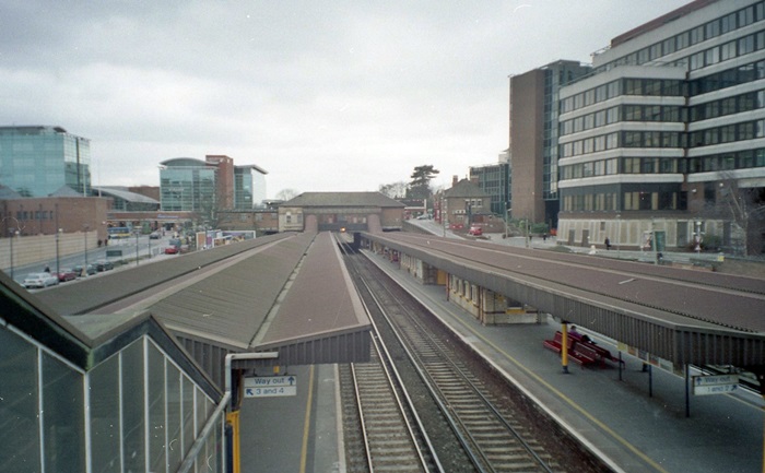
Westward views of the station ''up high'' can still be afforded from the 1959 footbridge, but the abolition of the public footbridge and advent of the road to the east in 1990 has blocked such scenes in the opposite direction. © David Glasspool
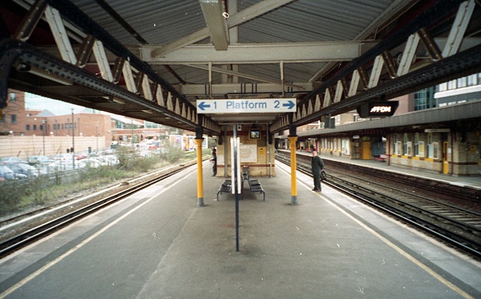
The grass verge on the left of this westward view was once occupied by an additional loop line, which is marked on the diagram seen earlier in this section. Beyond this loop was yet a third line; an eastward-facing coal siding. © David Glasspool
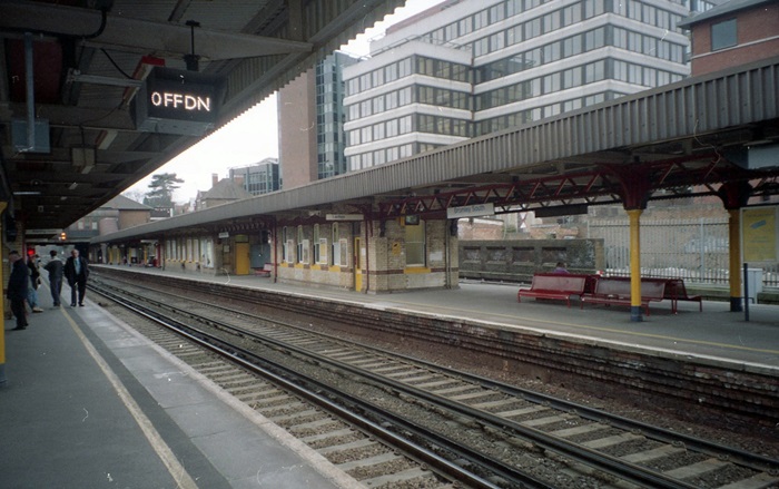
The palisade fencing on the right, beyond the platforms, separates the site from what was once the ''dock'' platform. The east to west downward gradient is indicated by the angle of the crème brick offices. © David Glasspool
Return to the Kent Rail Homepage or alternatively, check for Updates.
Website & Copyright information - Links - Contact the Webmaster
All content is copyright © David Glasspool unless otherwise stated